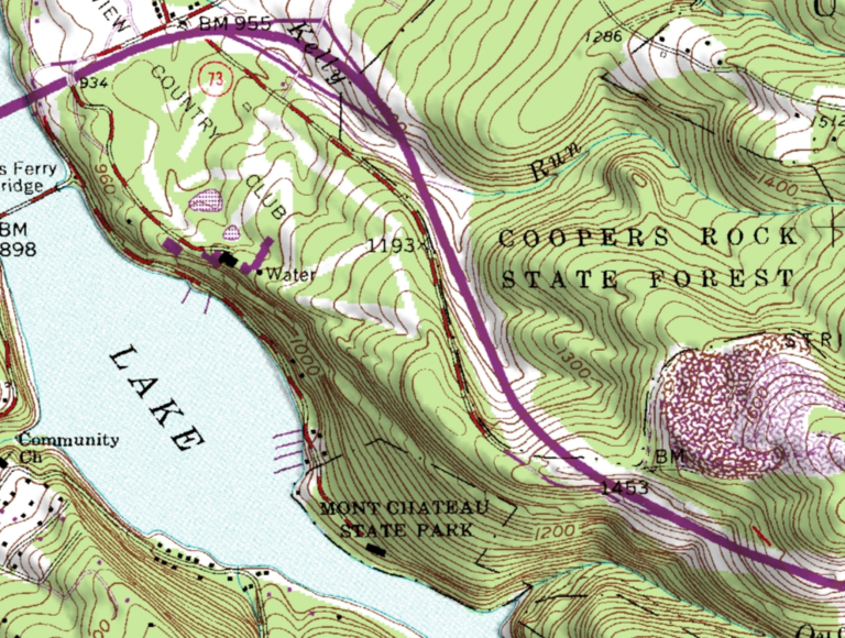
A Digital Raster Graphic (DRG) as TIFF is a georeferenced raster image of a published printed map. Files distributed in this format by USGS (U.S. Geological Survey) were scanned images of USGS topographic maps. The scanning was mainly done in 1995-98. The series of historical topographic maps distributed in DRG format on compact disc was retired starting in 2010.
USGS DRG images are stored in TIFF version 6.0 using PackBits compression (run-length encoding). DRGs are georeferenced to the plane ground coordinates of the Universal Transverse Mercator (UTM) coordinate system. The DRG product contains georeferencing information in three places for convenience of end users with different software tools: in the TIFF file following the GeoTIFF version 1.0 standard; in a separate metadata file; and in an optional ESRI_world file (*.tfw) which contains partial georeferencing information for the TIFF file. The USGS DRG product consisted of two mandatory physical files: the TIFF image and a text file of metadata, compliant with Federal Geographic Data Committee (FGDC) guidelines at the time. A third file, an ESRI_world file, as used by ArcGIS, was included, though this is not required by the product standard. The associated DRG image (.tif), world (.tfw), and metadata (.fgd) files incorporate an intelligent data set name (DSN) consisting of descriptive metadata wrapped around a standardized kernel that describes the spatial location of the file. The intent of this file naming protocol was to positively identify the spatial identity of the file and describe its categoric identity.
DRGs can be easily combined with other digital cartographic products such as digital elevation models (DEM) and digital orthophoto quadrangles (DOQ). DRGs were made by scanning published paper maps on high-resolution scanners. Colors are standardized to remove scanner limitations and artifacts.